
Mapping drones have revolutionized the surveying industry, providing a more efficient, safe, and cost-effective alternative to traditional mapping methods. They are used for various applications, such as infrastructure inspection, land area survey, and imagery capture for marketing purposes. The best mapping drones are outfitted with advanced features to deliver incomparable accuracy and efficiency.
These drones are designed with mapping-specific payloads, such as cameras and sensors. They capture images and data that can be processed into maps or 3D models.
Having the right drone can substantially affect the quality and accuracy of your results. We will walk you through all you need to know about the best mapping drones so that you are well-equipped to make a wise purchase.
What Is a Mapping Drone?
A mapping drone is an unmanned aerial vehicle outfitted with specialized cameras and sensors that gather geospatial data, which can be used to create detailed maps and 3D models for different environments.
Best Mapping Drones
Now that you know what a mapping drone is, let’s go straight to the top models.
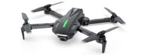
1) Autel Robotics EVO 2 PRO V3
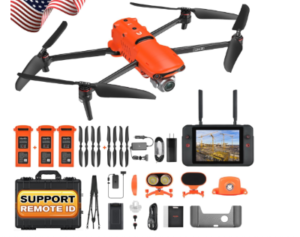
The Autel Robotics EVO 2 Pro V3 sets a new standard for mapping drones, combining advanced technology with user-friendly features to deliver unparalleled performance.
It features a fully improved, high-quality imaging system. It is equipped with a 1-inch CMOS sensor that captures 20MP photos and 6K video, ensuring exceptional clarity in every detail.
The enhanced Moonlight Algorithm 2.0 further refines image quality by effectively suppressing image noise, allowing for clear, detailed imagery even in low-light conditions.
The EVO 2 PRO V3 boasts an upgraded 15km image transmission, allowing operators to cover large areas without losing connection. This extended range is perfect for mapping expansive terrains, ensuring that every corner of the surveyed area is accessible and documented.
The drone is designed with versatility in mind, featuring an array of modular accessories that expand its functionality. The strobe light enhances visibility during nighttime operations or in low-light environments. The spotlight illuminates specific areas for detailed inspection and mapping in dark conditions.
Further, it has a loudspeaker that facilitates communication during missions and is useful for public safety operations and crowd management.
The state-of-the-art 7.9-inch touchscreen V3 smart controller is another reason this gadget is one of the best mapping drones. It provides a bright, clear display that is easily readable in sunlight, ensuring you can monitor your drone’s status and view real-time imagery without hassle. Its intuitive interface makes controlling the drone and accessing its features straightforward and efficient.
It is rugged and durable, ensuring reliability in diverse environments. Its high-performance propulsion system allows for stable and precise flight, which is critical for accurate mapping and surveying tasks.
Features
- 1080p video capture
- 15km image transmission range
- 1-inch CMOS sensor
- 9-inch touch screen V3 smart controller
- Suitable for beginners
- Includes batteries
Pros
- Good camera for both stills and videos
- Handles adverse wind with relative ease
- 360-degree obstacle avoidance
- Ease of set up
Cons
- There is a bad buzzing noise on the remote control
2) DJI Mini 4K Drone
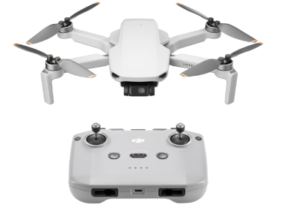
The DJI Mini 4K Drone boasts a powerful 4K Ultra HD camera, capturing stunningly detailed and vibrant aerial footage. Perfect for high-quality mapping and surveying tasks, this drone ensures that every detail is captured with utmost clarity. It is equipped with a 3-axis gimbal, which ensures that your footage is always smooth and stable, even in challenging flight conditions.
Weighing less than 249 grams, the DJI Mini 4K is incredibly portable and easy to carry. This lightweight design also means it falls under the registration requirements in many regions, making it a convenient choice for both hobbyists and professionals.
The mapping drone supports one-tap takeoff and landing, making it extremely easy to operate. Its intuitive controls and one-touch features make it accessible for novices, while advanced pilots will appreciate its precision and reliability.
The built-in GPS ensures accurate positioning and stable hovering, which is crucial for precise mapping tasks. The Return to Home (RTH) feature automatically brings the drone back to its takeoff point, ensuring safe and worry-free operation.
The gadget offers additional in-app learning resources for those new to drone flying. These tutorials and guides help users quickly master the basics of flight and advanced functionalities, ensuring a smooth learning curve.
Moreover, it can withstand wind speeds up to 38 kph (Level 5) and perform reliably in various weather conditions. This wind resistance ensures consistent performance and safety during mapping missions.
The DJI Mini 4K Drone features a maximum HD video transmission range of up to 10 kilometers, providing extensive coverage and flexibility for large mapping areas. This long-range capability ensures uninterrupted live feed and control, even at significant distances.
Features
- 3-axis gimbal
- 4K Ultra HD
- Weighs less than 249g
- Long distance control
- 10 km max HD video transmission
- One touch easy operation
- Auto return to home
- 38kph wind resistant
Pros
- Effortless and safe to fly
- Easy to carry and use
- Decent battery time
Cons
- No obstacle avoidance sensors
3) Potensic Atom 3-Axis Gimbal 4K GPS Drone
The Potensic Atom Drone is a palm-sized drone equipped with a 4K camera and a 3-axis gimbal. It delivers rock-steady footage with exceptional clarity and detail. This setup ensures professional-grade mapping results, precisely capturing every nuance of the terrain.
Weighing less than 249 grams, the drone is remarkably portable and easy to carry. Its lightweight design exempts it from many regional registration requirements, making it ideal for both casual users and professional surveyors.
It features SurgeFly technology, allowing a maximum transmission range of up to 6 kilometers. This extended range provides comprehensive coverage and flexibility for extensive mapping projects, ensuring you can survey large areas without losing connection.
The drone’s enhanced GPS capabilities offer precise positioning and stable flight. These features contribute to steady aerial shots, which are critical for accurate mapping and surveying. The GPS ensures the drone maintains a fixed position, even in challenging conditions.
The Return-to-Home (RTH) feature ensures the drone returns safely to its takeoff point with just a tap on your phone. This functionality enhances operational safety and provides peace of mind, particularly for novice pilots.
As one of the best mapping drones, it supports 1.5-hour fast charging, minimizing downtime between flights. With three batteries included, it offers a total flight time of up to 96 minutes, allowing for extended mapping sessions without interruption.
Features
- 12MP camera
- Sony CMOS sensor
- Weighs less than 249g
- Upgraded PixSync 3.0 technology
- 3-axis brushless gimbal
- Enhanced GPS capabilities
- 5H fast charge
- Return to home feature for steady shots
- Includes a storage bag for easy carrying
Pros
- Compact and lightweight
- Superb image quality
- Easy to use
Cons
- No collision avoidance
4) DEERC D70 Mini Drone
The DEERC D70 drone is so good. It has a comprehensive feature set to deliver high-quality results. Its combination of user-friendly features, intelligent control options, and high-quality imaging will have you sold.
The drone is equipped with a high-quality 1080P HD Wi-Fi camera that captures sharp and vibrant aerial photos and videos. This clarity is essential for mapping tasks, ensuring every detail is visible. The Wi-Fi real-time transmission feature allows you to instantly share your captured moments, making it perfect for both professional and recreational use.
It is designed with user convenience in mind. Its One-key Takeoff/Landing makes it extremely easy to operate. You can master the controls of this first-person view drone within just 10 minutes, making it easy to learn for beginners while still providing advanced features for experienced flyers.
The drone’s foldable design makes it highly portable and easy to carry. Whether going on a trip or conducting a mapping project in different locations, its compact form ensures it fits easily into your backpack or carrying case.
The DEERC D70 offers a range of intelligent app control features, allowing you to operate the drone with your cellphone. You can customize the drone’s flight path using TapFly, control it with Voice Commands, and capture moments with Gesture Selfie.
The Throw-to-Go feature lets you launch the drone by simply throwing it into the air, and the 360° Flips, High-Speed Rotation, and Circle Fly functions add a fun and dynamic element to your flights.
Another highlight that makes it one of the best mapping drones is the Altitude Hold, which ensures the drone maintains a steady height, which is crucial for capturing consistent and stable images during mapping. Headless Mode simplifies control by aligning the drone’s orientation with the pilot, making navigation easier and more intuitive.
Features
- High-speed rotation
- 360-degree flip
- Altitude Hold
- One-key takeoff/landing
- 1080P HD Wi-Fi camera
- Intelligent App control
- Headless mode
- Emergency stop
- Voice control
Pros
- Incredibly easy to fly
- Robust
- Very stable in flight
Cons
- Some concerns about it being hard to control
5) Bwine F7 GPS Upgraded Drone
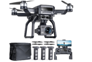
The Bwine F7 GPS Upgraded Drone has a high-resolution 4K camera, delivering stunningly detailed and clear aerial photos and videos. This is essential for precise mapping and surveying, ensuring that all aspects of the terrain are captured in exceptional detail.
It features Intelligent Route Planning, allowing you to set predefined flight paths for comprehensive mapping coverage. This feature ensures efficient and systematic data collection, perfect for professional mapping projects.
The VR Split Screen Interface enhances your flying experience by providing immersive first-person view (FPV) capabilities. This feature lets you view the live feed from the drone’s camera as if you were on board, making navigation and mapping more intuitive and engaging.
With a maximum flight distance of 1640 feet, the drone provides extensive coverage for large mapping areas. This extended range ensures that you can survey vast regions without frequently repositioning the drone.
It is lightweight and features a foldable design, making it easy to transport and store. This portability is ideal for fieldwork, allowing you to effortlessly carry the drone to various locations, making it one of the best mapping drones.
The One Button Return feature ensures the drone returns safely to its takeoff point with a single press. This adds an extra layer of safety and convenience, especially during complex mapping missions.
The Optical Flow positioning system allows the device to fly stably indoors, where GPS signals might be weak or unavailable. This ensures accurate and stable flights in all environments, making it versatile for indoor and outdoor mapping tasks.
That is not all. The Bwine F7, which is one of the best mapping drones, offers extended flight times, allowing you to cover more ground without frequent battery changes. This efficiency is crucial for large-scale mapping projects, minimizing downtime and maximizing productivity.
Features
- One button return
- A weight of 248g
- 4K UHD camera
- GPS and optical flow mode
- Intelligent route planning
- 1640 feet flight distance
- VR split screen interface
- 7K real-time image transmission
Pros
- Great build quality
- Excellent range
- Ease of setup and use
Cons
- Relatively low responsiveness
Choosing the Best Mapping Drones
Some key pointers to look at before investing in a mapping drone include:
Autonomous Flight Capability
Aerial mapping surveys often require multiple flights over an area to obtain consistent and accurate data. Maintaining the exact flight path manually is virtually impossible, so drones with programmable autonomous flight capabilities are essential.
Using specialized software, flight paths can be formed and transmitted to the drone’s remote controller, minimizing human error.
Real Time Kinematic Compatibility
This technology enhances GPS data accuracy in mapping drones through various measurements. Constant correction of GPS data relative to a fixed ground station can achieve centimeter-level locational accuracy.
Although Real Time Kinematic drones are pricey, their enhanced accuracy makes them invaluable for urban planning and construction fields.
Battery Life
The battery life is the third thing to consider when looking for the best mapping drones. Long battery life is vital for mapping vast areas. A professional drone with a longer flight time, such as 50 to 60 minutes, can map a field that is larger than an acre or two. A drone with a flight duration of only 25 to 30 minutes cannot do so.
Payload Capacity
This is the amount of weight a drone can carry. The best mapping drones should have a payload capacity of at least 2 to 3 pounds, which is adequate to carry a 4K camera and a gimbal for stabilization. The drone can have several sensors installed for mapping purposes.
Gimbal Stabilization
A gimbal stabilizes the camera during flight, ensuring sharp, undistorted images are captured, which is instrumental for high-quality mapping.
High-Resolution Camera
The best mapping drones have a 4K camera which is vital for taking detailed, high-resolution photos and videos necessary for providing clear and accurate models.
Benefits of Using Drones for Mapping?
Better Accuracy
The best mapping drones have cutting-edge sensors and GPS capabilities that provide precise data for detailed analysis.
Improved Safety
Drones remove the need for mappers to access rugged or hazardous terrain, minimizing the risk of injuries and accidents.
Reduced Time and Cost
Drones can cover large areas in less time than traditional methods, significantly saving costs.
Easy Data Collection and Processing
Modern mapping drones feature software and data processing tools that streamline mapping and allow for effortless integration with GIS and CAD platforms.
What Is Needed for Drone Mapping?
Drone mapping combines a range of technologies, such as photogrammetry, LiDAR, and SLAM lidar, to generate high-resolution images and data that can be utilized for surveying, construction, environmental monitoring, and agriculture.
Photogrammetry or measurement from photos is typically the core technology for drone mapping.
What Influences Photo Quality in Drone Mapping?
A couple of factors affect the clarity of images taken by mapping drones:
Camera Distance from Target
The camera’s focal length determines the distance from which an object can be clearly captured. Larger drones with wider prop spans can work effectively from greater distances, which is useful for detailed 3D modeling.
Altitude
Optimal altitude is vital to balance clarity and detail visibility in aerial images.
Sunlight and Shadows
The time of day and position of the sun can cast shadows that obscure details or features in aerial photographs, affecting the mapping quality.
Environmental Conditions
High altitudes and long-distance flights often face issues like increased wind speed and physical obstructions, which can make drone control complex.
Conclusion
We hope this review of the best mapping drones has provided valuable insights. We have listed the top-performing drones and factors to consider before purchasing to ensure you have all the information you need. We hope you have found a suitable model for yourself.
Related: 5 Best Night Vision Drones